Site Surveys and Path Loss for Microwave Paths in the Fort Berthold Reservation
I should preface this report as I am getting conflicting elevation
data from my 3 second data supplied by the USGS and the Ft. Berthold
elevation contour maps supplied by the tribe. Where there is a
significant discrepancy between the two, I will call it out in the
report. - Tim
Summary...
The objective for Ft. Berthold was to look into replacing the
current copper or DS-1 infrastructure for remote education to the
communities of White Shield, Twin Buttes and Mandaree. Unfortunately
these towns are a significant distance away from the current FBCC
building and each other. Terrain is also problematic as these
long paths have obstructions that would require significant tower
height and/or some mid-point repeater.

The New FBCC to KMHA-FM
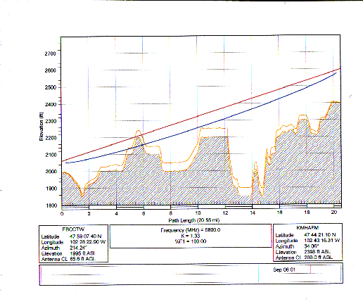
The path...
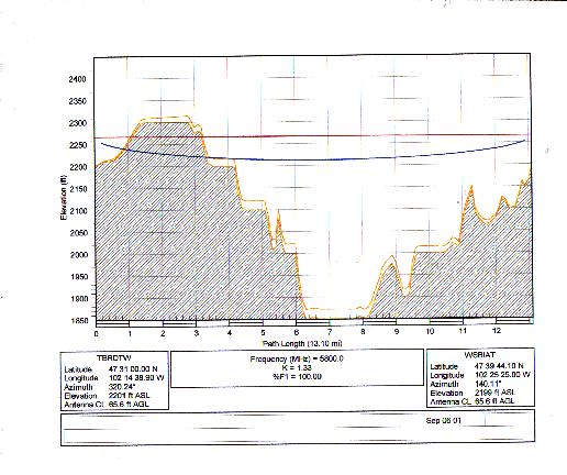
The first path attempt is to get down to Mandaree from the FBCC
site.
At the FBCC we found an abandoned tower about 800 feet due north
of the building. This tower is co-located with the town's water
towers on a 50' hill. The tower height is estimated at 60'. It
is currently a self supporting triangular tower with 3' faces.
Although there are signs that there was power at the tower, currently
it is not plumbed in. There is a small box next to the tower were
the power once ran into. The box is not a rack nor big enough to
contain our gear.
The reservation has one Tribal owned FM broadcast station
(KMHA) with a tower
([Image1]
[Image2]) located next to Mandaree.
The studios are located next to the tribal offices about 4.7 miles
due west. Their studios pass programming to the transmitter site
with a 950MHz studio to transmitter link (STL). The overall height
of the tower is 377' with the top portion supporting a 12 bay
antenna for the FM transmitter. This takes about 164'. There is
some room just below this array at about the 200' level. The KMHA
STL antenna is about mid point up the tower.
With the assumption of the AGL for the antennas and ASL of these
towers we have some intrusion in the path about 5.6 miles out from
the FBCC tower. With the earth bulge calculated in it blocks the
center of radiation. Raising the antenna to 170' AGL at the FBCC
tower would clear it.
Path Calculations...
Path assumptions and performance calculations can be found here.
NOTE: One
change in this calculation over the others is using 5/8" transmission
line (LMR-900) for the KMHA site as we need at least 200' for this
location.
Assuming we have a clear shot with the AGL needed on both ends,
with 8' dishes we would have a fade margin of 16.3 dB and an uptime
of 99.925831% or outages totaling 389.83 minutes a year as there
is a some distance on this link.
Technical needs...
We need to determine if the abandoned tower next to the FBCC building
is available. If so, some structural engineering will be needed
to determine if it can support weight and wind load of two 8'
dishes and extending the height to about 130'. Likely guying or
even a new tower will be need.
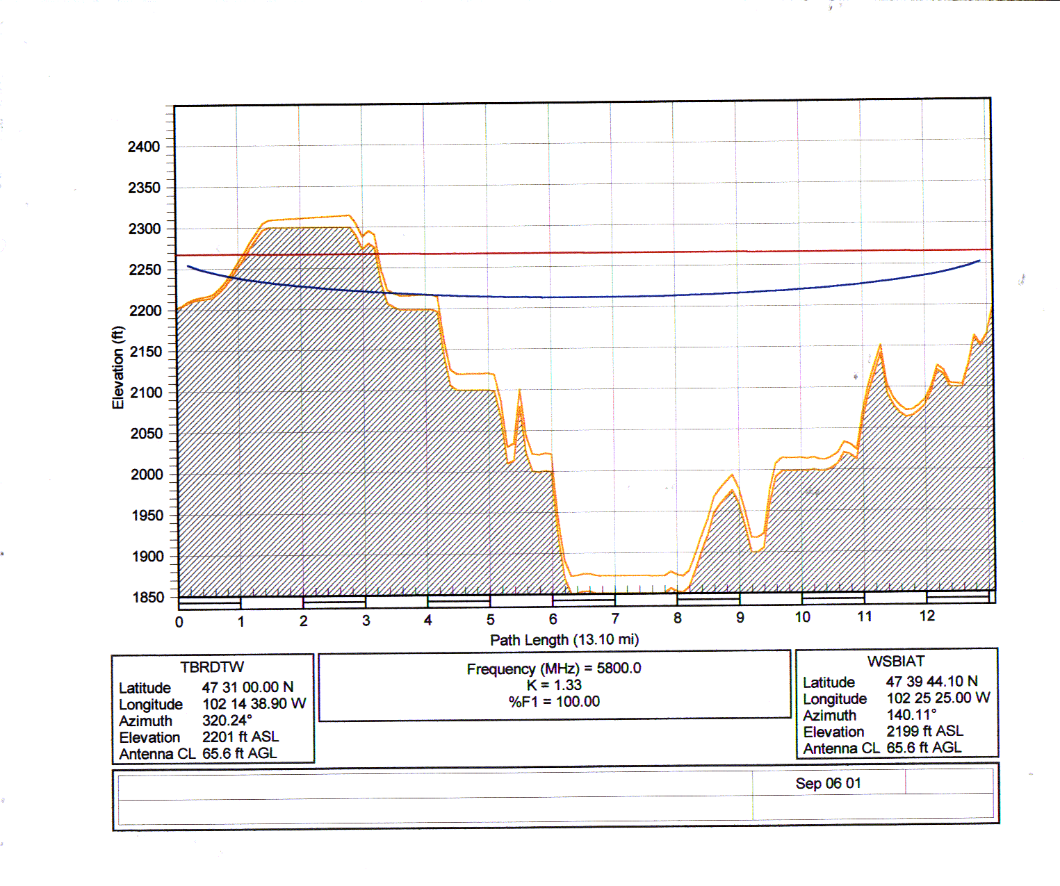
KMHA-FM to Twin Buttes Tower
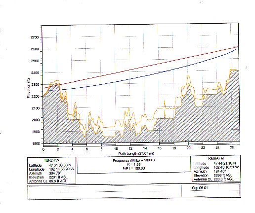
The path...
The only tower found in Twin Buttes was the one the BIA has (had?).
This tower is a light weight guyed tower with a 1' face. An
estimated height is about 70'. The tower will need to have a
structural engineer review as it is pretty light weight for the
weight and wind loading of 8' dishes. There is a building (garage)
about 50 feet away that could contain a rack and has power.
As Twin Buttes is 27 miles south east of Mandaree. The path must
go over the Missouri River and some hills or buttes just south of
the river before Twin Buttes such as "Old Man Dancing Butte at
2242'. Unfortunately these hills are higher than the ASL of the
tower and cut into the path. There are two ways to approach this.
Either build another tower on one of the buttes or raise the BIA
tower another 100' to get an AGL of 170'. For this section we
are just going to look at the path calculations for the current
BIA tower location.
Path Calculations...
Path assumptions and performance calculations can be found here.
Assuming we have a clear shot with the AGL needed on both ends,
with 8' dishes we would have a fade margin of 16.3 dB and an uptime
of 99.669931% or outages totaling 1,734.84 minutes a year as there
is a some distance on this link. This is not the four "9s" or
three "9s" that was asked for by the FBCC staff.
Technical needs...
A structural engineering review of the Twin Buttes BIA tower should
be done to determine if the tower can be extended and support the
wind loading and weight of the two 8 foot dishes. If not we need
to determine if we want to replace this tower or find another site
such as up on the buttes.
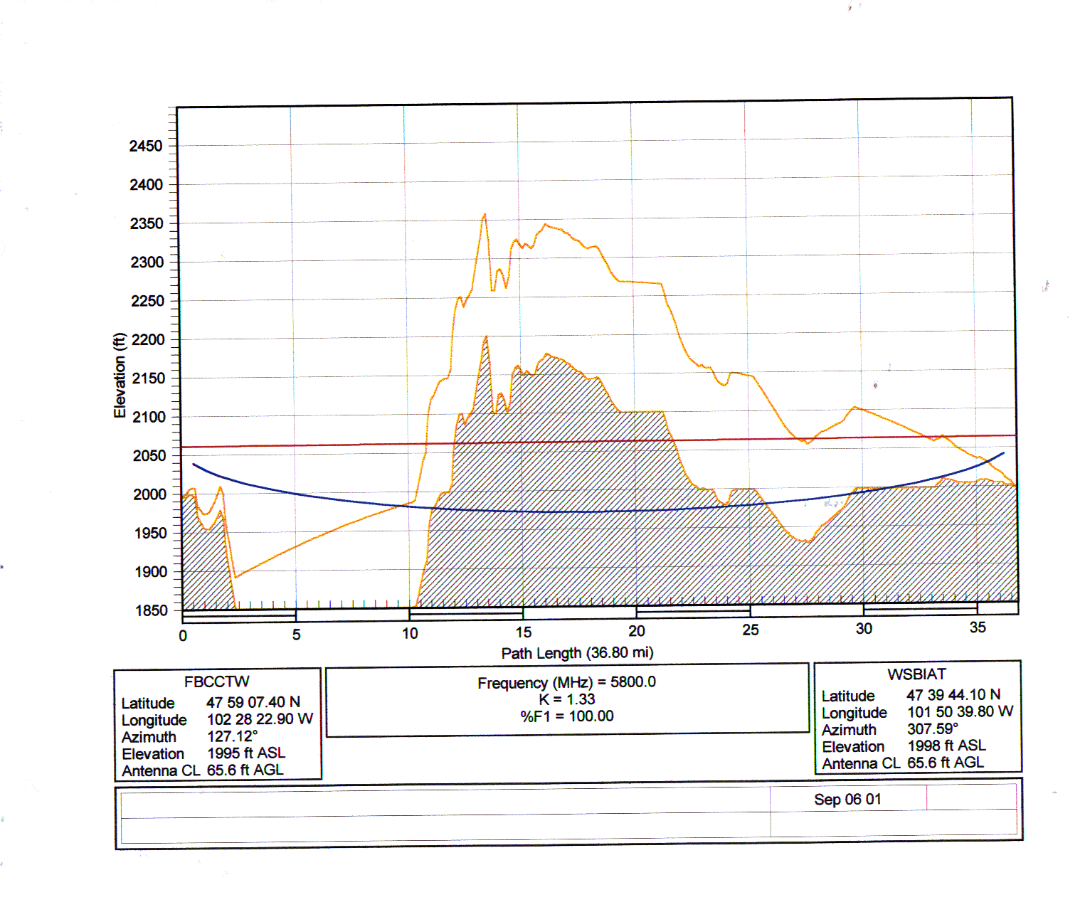
An Alternative Path From KMHA-FM Tower to Twin Buttes Tower via the Mandaree Weather Tower
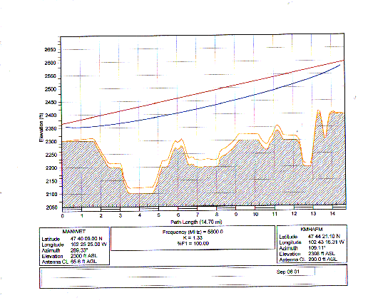
First Hop
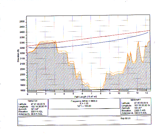
Second Hop
The path...
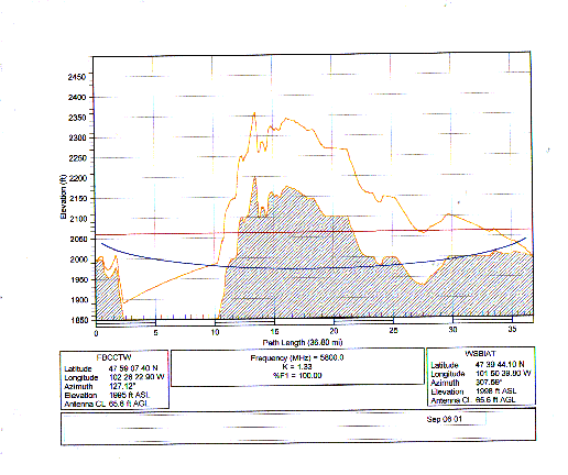
One way to raise the "up time" of the link would be to have shorter
paths. A tower was found about half way between the KMHA and Twin
Buttes BIA towers on a road out of Mandaree on the way to Mc Kinsey
Bay. This tower ([Image1] [Image2] [Image3])
was also owned by BIA and has a rather extensive weather station
next to it with a radio link to send the data back. The tower is
guyed with a 1' face and the height is estimated at 120'. Clear
portions of the tower are at about the 80-90' and 100-110' levels.
There is a downside as there is an additional link for this path.
Maintenance costs go up as well as the initial equipment and installation
costs.
Path Calculations...
Path assumptions and performance calculations for the first hop
can be found here and
the second hop here.
Again, assuming we have a clear shot with the AGL needed on both ends,
with 8' dishes we would have a fade margin of 18.7db with an uptime
of 99.984413% or outage of 81.92 minutes per year. If we reduced
this to 6' dishes the fade margin would be 13.7dB with an uptime
of 99.950711% or outage of 259.06 minutes per year.
Technical needs...
A structural engineer would need to examine this mid-point tower as
it is a light weight antenna. This path also has the same problem
in getting into Twin Buttes with the AGL of the antennas on the
Twin Butte's tower as we need the same 170' AGL there. We still
need to address that as outlined above.
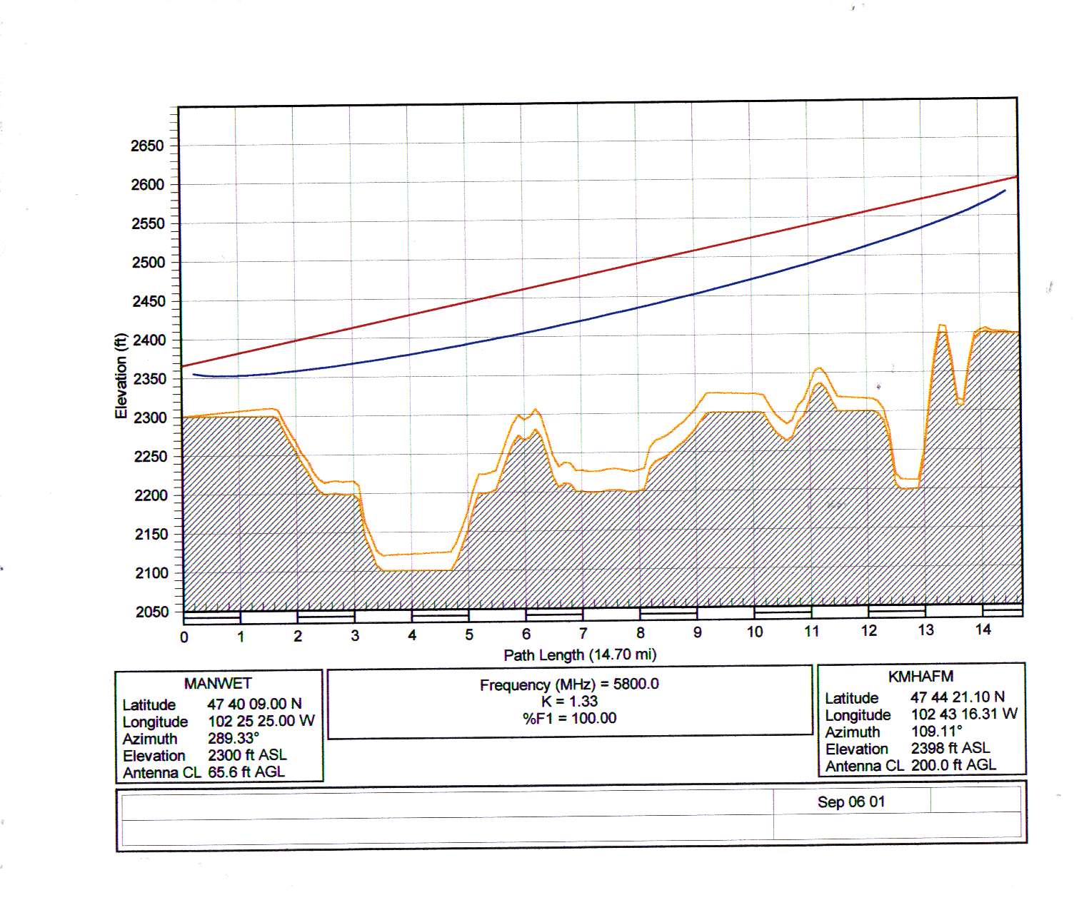
Twin Buttes Tower to White Shield Tower
The path...
A tower was identified in White Sheild as a good candidate. This
looks much the other BIA towers as it is a 1' face, guyed tower
about 70' tall. This tower does have a "radio shack" with power
next to it.
Looking at the path from Twin Buttes to this tower in White Sheild
we see the same issue where a butte about 2 miles from Twin Butte
is blocking the path. An AGL of 170' on the Twin Buttes' tower
would be needed to clear this path. If we could clear the butte,
this path will work. This revisits the issues with the Twin Buttes
tower as outlined above.
Path Calculations...
Path assumptions and performance calculations can be found here.
Assuming we have a clear shot with the AGL needed on both ends,
with 6' dishes we would have a fade margin of 17.2 dB and an uptime
of 99.984422% or outages totaling 81.88 minutes a year. 4' dishes
would get us 10.4 dB of fade margin with a 99.925437% uptime or
391.90 minutes per year of outages.
Technical needs...
See above regarding the Twin Buttes tower.
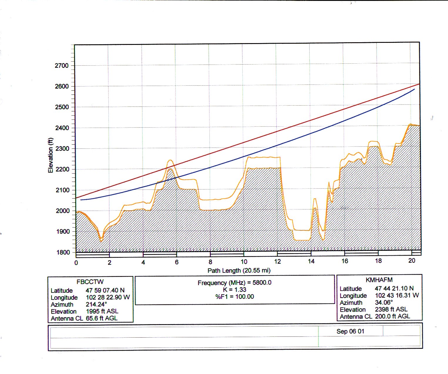
White Shield Tower to FBCC Tower
The path...
In order to creat a ring around the reservation we need to close
it by putting a path between White Shield and the Fort Berthold
Community College tower. Unfortunately this path is very long and
has some obstructions where the AGL of both antennas would have to
be about 450'.
Path Calculations...
Path assumptions and performance calculations can be found here.
If it could ever get this path to work, with 8' dishes at 450' AGL
and switching to Andrew EW-52 (6GHz Waveguide) we would have only
15.2 dB of fade margin. With this distance we would have 99.456245%
uptime or 2,857.98 minutes per year of outages.
Technical needs...
Two very tall towers or something in between these sites...
Version:
$Id: pathloss_report.html,v 1.8 2001/09/29 16:39:08 pozar Exp $


![[Image1]](KMHATwr_base.jpg)
![[Image2]](KMHATwr_up.jpg)